
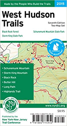
West Hudson Trails Map
Member Price: $8.60 Join now
Please enter your Member promo code in checkout to receive your 10% discount.
Printed in vibrant color on waterproof and tear-resistant Tyvek, this revised, digitally-produced two-map set is a must-have for outdoor enthusiasts interested in exploring the trails and parklands west of the Hudson River in the Hudson Highlands of Orange County, New York.
The maps in this set feature:
- Nearly 70 miles of marked trails in Orange County, New York
- Parklands including Black Rock Forest, Schunemunk Mountain State Park, and
Storm King State Park
- More than 10 miles of the Long Path and nearly 25 miles of the Highlands Trail
- Detailed trail mileage numbers
- 20-foot elevation contours
- 1:20,000 scale (1 inch = 0.32 mile)
- Convenient map sizes to carry and use on the trail
- Inset map showing a portion of Orange County's Heritage Trail
- Parkland boundaries
- Unmaintained trails and woods roads
- Viewpoints, mines, springs, and other points of interest
- Parking areas and bus stop locations
- Trail descriptions, park contact information, history, and regulations
- UTM coordinate grid
Built on more than 75 years of mapping experience, New York-New Jersey Trail Conference maps are your source for reliable trail information in the New York-New Jersey metropolitan region. These maps are Made By the People Who Build the Trails and are regularly updated with changes to the trails.